USGS LiDAR CLI Tool
A command-line interface tool for downloading USGS LiDAR data based on GeoJSON boundaries.
Data Source
Data is accessed via the Registry of Open Data on AWS. For more details and information on how to cite see the USGS 3DEP LiDAR Point Clouds
Features
- Download LiDAR data from USGS 3DEP datasets using GeoJSON boundary files
- Automatically identify intersecting USGS LiDAR datasets
- Create visualizations with basemaps showing data coverage and overlaps
- Support for prioritizing the most recent datasets
- Dry-run mode to check for available data without downloading
Coverage
- Coverage is based on the USGS public lidar boundaries at: https://raw.githubusercontent.com/hobu/usgs-lidar/master/boundaries/resources.geojson
- Some areas have no coverage. See
usgs_lidar_boundaries.gpkg
Installation
Prerequisites
- Python 3.7 or higher
- PDAL (Point Data Abstraction Library) installed and available in PATH
Install from source
The easiest way to install is to use the provided installation script:
# Clone the repository
git clone https://github.com/DHersh3094/USGS-LiDAR-CLI-Tool.git
cd USGS-LiDAR-CLI-Tool

# Run the installation script
bash install_and_test.sh
This script will:
- Create a virtual environment
- Install the package and its dependencies
- Create global command links for easier access
- Run basic tests to verify the installation
Alternatively, you can install manually:
# Clone the repository
git clone https://github.com/DHersh3094/USGS-LiDAR-CLI-Tool.git
cd USGS-LiDAR-CLI-Tool

# Create and activate a virtual environment
python -m venv venv
source venv/bin/activate

# Install the package
pip install -e .

# Create command links (optional)
mkdir -p ~/.local/bin
ln -sf "$(pwd)/venv/bin/USGS-LiDAR-CLI-Tool" ~/.local/bin/USGS-LiDAR-CLI-Tool
ln -sf "$(pwd)/venv/bin/USGS_LiDAR_CLI_Tool" ~/.local/bin/USGS_LiDAR_CLI_Tool
After installation, you may need to run source ~/.bashrc to update your current shell, or open a new terminal window.
Usage
Command Line Options
--geojson,-g: Path to input GeoJSON file defining the boundary (required)--output-dir,-o: Output directory for downloaded LAZ files (default: lidar_data)--dry-run,-d: Find intersecting datasets but don’t download files--resolution,-r: Resolution to use for the data in Entwine Point Tile (EPT) format. Use ‘full’ for native resolution (all points), or specify a numeric value in coordinate units (meters) to control point spacing. For example, 1.0 will retrieve points with ~1m spacing, 0.5 creates denser point clouds, and 2.0 creates sparser data. Lower values = more detail and larger files. (default: ‘full’)--coordinate-reference-system,-crs: EPSG code to reproject laz files during download--classify-ground: Add smrf ground classification (default: false)--outlier-filter: Apply statistical outlier filter to point clouds during download removing noise points from the output. For more details, see the PDAL filters.outlier documentation.--outlier-mean-k: Number of nearest neighbors to consider for outlier filter (default: 12)--outlier-multiplier: Standard deviation multiplier threshold for outlier filter (default: 2.2)--verbose,-v: Enable verbose logging--most-recent: Use only the most recent data when multiple datasets overlap--no-visualization: Skip creating visualization of datasets and boundary
Examples
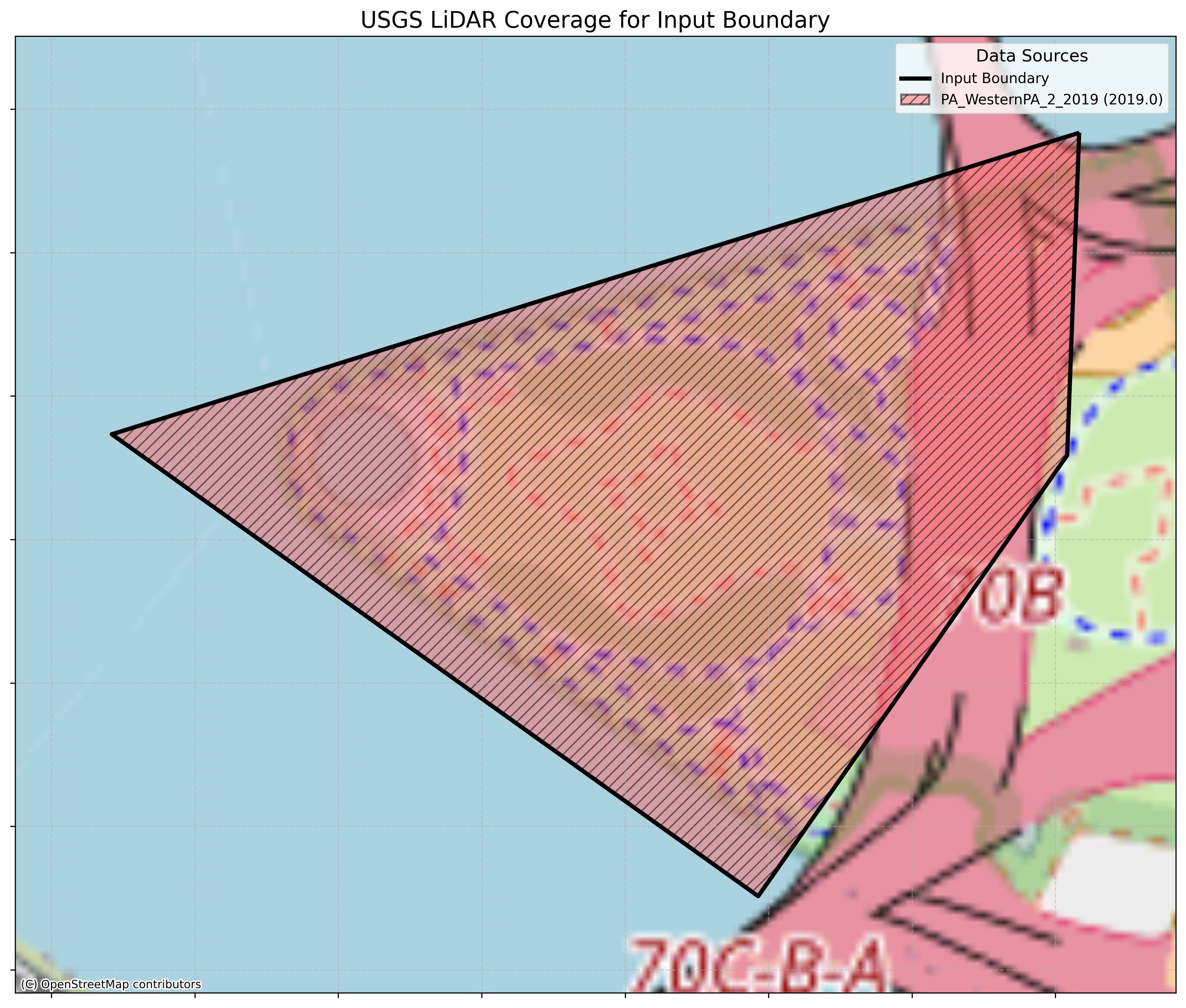
Check available datasets without downloading:
USGS-LiDAR-CLI-Tool --geojson demo.geojson --dry-run
Creates an image:
Then download all intersecting pointclouds (in this case only 1) with a target CRS and an outlier filter:
USGS-LiDAR-CLI-Tool --geojson demo.geojson \
--coordinate-reference-system 32617 \
--outlier-filter
Logs are saved to demo_info.txt
USGS LiDAR Downloader Report
Generated on: 2025-05-18 11:37:24
Input GeoJSON: demo.geojson

Intersecting Datasets (1):
  1. PA_WesternPA_2_2019 (2019.0)

Download Strategy: All intersecting datasets

Download Log:
  - Successfully downloaded 1 files from PA_WesternPA_2_2019
    Output file: demo_PA_WesternPA_2_2019.laz

Each dataset was downloaded to a separate file.
A copy of the PDAL pipeline is also saved as demo_PA_WesternPA_2_2019_pipeline.json:
{
    "pipeline": [
        {
            "type": "readers.ept",
            "filename": "https://s3-us-west-2.amazonaws.com/usgs-lidar-public/PA_WesternPA_2_2019/ept.json",
            "polygon": "{\"coordinates\": [[[-80.00830228623919, 40.44337798148942], [-80.01436057451653, 40.4419411606153], [-80.01031232296975, 40.43973940536199], [-80.00837742779959, 40.44184108239551], [-80.00830228623919, 40.44337798148942]]], \"type\": \"Polygon\"}"
        },
        {
            "type": "filters.reprojection",
            "out_srs": "EPSG:32617"
        },
        {
            "type": "filters.outlier",
            "method": "statistical",
            "mean_k": 12,
            "multiplier": 2.2
        },
        {
            "type": "filters.range",
            "limits": "Classification![7:7]"
        },
        {
            "type": "writers.las",
            "filename": "lidar_data/demo/demo_PA_WesternPA_2_2019.laz",
            "minor_version": 4,
            "dataformat_id": 8
        }
    ]
}
Output
The tool creates an organized directory structure:
- Each GeoJSON input gets its own subfolder
- Visualizations show dataset coverage
- Detailed info.txt file with dataset information
- Copy of the PDAL pipeline
- LAZ files are named after the input GeoJSON
Known Issues and Bugs
Date Parsing Issues
- Dataset Year Parsing: Some USGS dataset bucket names have non-standard formatting that prevents correct date/year extraction. For example, buckets like “AR_NorthEast_1_D22” will not have their dates parsed correctly, which can impact the
--most-recentfunctionality and visualization year labels.
To do:
- Add bulk download support using an input GeoPackage
- Add other PDAL commands to pipeline
- Colorization based on best matching NAIP imagery
License
GPL 3-Clause. See LICENSE file for details.